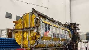
NASA-ISRO Satellite NISAR getting ready for 2024 launch

Stay tuned with 24 News HD Android App

NISAR is an Earth-observation satellite built jointly by NASA and the Indian Space Research Organization (ISRO) that is expected to be launched in January 2024 from India into a near-polar orbit, reported 24NewsHD TV channel.
NISAR aims at to make global measurements of the causes and consequences of land surface changes using advanced radar imaging.
NISAR got a send-off ceremony at the American space agency’s Jet Propulsion Laboratory (JPL) in Southern California on Friday.
It has been built by space agencies of the US and India under a partnership agreement signed in 2014. The 2,800 kilograms satellite consists of both L-band and S-band synthetic aperture radar (SAR) instruments, which makes it a dual-frequency imaging radar satellite.
Once launched into space, NISAR will provide critical information on Earth’s crust, ice sheets, and ecosystems, helping researchers better understand the causes and consequences of land surface changes.
It will spot warning signs of natural disasters, such as volcanic eruptions, earthquakes and landslides. The satellite will also measure groundwater levels, track flow rates of glaciers and ice sheets, and monitor the planet’s forest and agricultural regions, which can improve our understanding of carbon exchange.
The SUV-size satellite will be shipped to India in a special cargo container flight later this month for a possible launch in 2024 from Satish Dhawan Space Centre in Andhra Pradesh.
LIVE: Go inside @NASAJPL for a look at NISAR, an Earth-observing satellite built in partnership with @ISRO. The mission is set to launch from India in 2024. https://t.co/6Hi8AyIQ1D
— NASA (@NASA) February 3, 2023
“This mission will be a powerful demonstration of the capability of radar as a science tool and help us study Earth’s dynamic land and ice surfaces in greater detail than ever before.”
While NASA has provided the L-band radar, GPS, a high-capacity solid-state recorder to store data, and a payload data subsystem, ISRO has provided the S-band radar, the GSLV launch system and spacecraft.
ISRO will use NISAR for a variety of purposes including agricultural mapping, and monitoring of glaciers in the Himalayas, landslide-prone areas and changes in the coastline.
According to NASA, “the instrument’s imaging swath — the width of the strip of data collected along the length of the orbit track — is greater than 150 miles (240 km), which allows it to image the entire Earth in 12 days.
The satellite will operate for a minimum of three years. NASA requires the L-band radar for its global science operations for at least three years. Meanwhile, ISRO will utilise the S-band radar for a minimum of five years.
