Indian expansionist design in Ladakh

Stay tuned with 24 News HD Android App

Daulat Beg Oldie (DBO) is a historic campsite and current Indian military base located on an ancient trade route connecting Ladakh (Indian Occupied Kashmir) to the Tarim Basin (China). It is named after Sultan Said Khan (Daulat Beg), who died here on his return journey after the invasion of Ladakh and Kashmir. The Chip Chap River flows just to the South of Daulat Beg Oldie from East to West. Daulat Beg Oldie also has an airstrip at an altitude of 5065 meters (16,614 feet), which happens to be the world's highest airstrip. DBO lies near the easternmost point of the Karakoram Range in a cold desert region in the far North of IOK just 8 km south of the Chinese border and 9 km northwest of the Aksai Chin Line of Actual Control (LAC) between China and IOK. Other than Siachen Glacier military bases, it is India's Northernmost settlement. The nearest civilian town is Murgo to the South, which has a small population of Baltis.
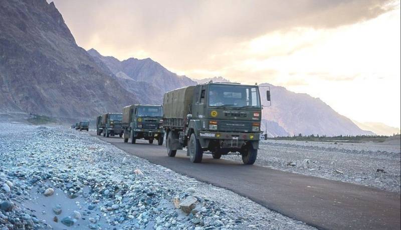
The Indian government first announced plans in 2001 to construct a motorable road from Leh to DBO. The 255 km Darbuk-Shyok-DBO (DSDBO) road was completed in October 2019 and it runs at elevations between 4,000–5,000 metres (13,000–16,000 ft). The temperature plummets as low as -55 C in the winters. The weather deteriorates frequently with strong icy winds lashing much of DBO. DBO has very little if any vegetation or wildlife. Communication is possible only through satellite phones.
In the last one year or so, India has upgraded the base and deployed two Brigades (81 and 114 Brigades) in DBO and surrounding areas and one brigade (70 Brigade) in Himachal Sector in Eastern Ladakh. In the recent past, India has been actively engaged in developing lateral roads connecting with the main artery in the area i.e. DSDBO Road. These 3 Brigades in DBO and Eastern Ladakh areas can augment operations in Siachin Glacier besides threatening the Chinese border posts in Aksai Chin and Tibet areas
These developments coupled with the recent change of constitutional status of IOK and issuance of new Indian Maps showing GB and AJ&K as part of India have created an alarming situation for Pakistan and CPEC. China had been patiently watching the situation and tried to convince the Indian Leadership to develop some sort of understanding with Pakistan and China, but Modi, backed by the US continued to pursue India’s hegemonic policies.
Consequently, in the 3rd week of April 2020, some skirmishes took place between the patrols of Peoples Liberation Army (PLA) and the Indian Army along the LAC opposite Ladakh. On the night of May 5/6, PLA soldiers suddenly crossed into Galwan River Valley in southern Ladakh and made a 4-5 km deep penetration. Western ridges were occupied. The other incursion was in Pangong Tso Lake in Eastern Ladakh bordering Tibet at a distance of 10 km, where the entire area between Finger 5 and Finger 8 along the northern bank was captured. Other points of intrusions were in Hot Springs in Ladakh’s Chang Chenmo River Valley and at Demchok. On May 9 yet another attack was put in on Naku Lu Pass in Northern Sikkim. In Pangong Tso and Naku Lu 72 Indian soldiers were injured and dozens of Indian soldiers were abducted, humiliated and then released. An Indian helicopter carrying Corps Commander X1V Corps was chased away by two Chinese helicopters. PLA rebuffed requests of Indian military for a flag meeting.
While Indian troops deployed in the area didn’t put up any resistance and begged for reinforcements from Northern Command HQ at Udhampur, PLA soldiers secured 15-20 sq km area in Galwan Valley and 10 km in Pangong area, pitched tents, dug bunkers, brought forward a large number of combat and earth-moving vehicles, heavy guns, artillery and tanks, and fully activated the Ngari airbase in Indus Valley, 50 km away from LAC and Demchok, and 180 km away from Pangong Tso, where fighter jets are parked. India had no idea when the jets were brought in. Chumar is the only Indian location which can threaten Ngari. PLA deployed a brigade each in Galwan River Valley and Pangong Tso areas. Troops were also deployed at Depsang Plains, Hot Springs, Spangur Gap and Chumar as well as in Naku La, DBO area. In the Central sector as well as opposite Arunachal Pradesh, another brigade was deployed. This enabled deployment of about 10,000 troops against 3-4 Brigades deployed by India. These Indian brigades have been pulled out from eastern border facing Pakistan.
The recent Chinese manoeuvres in Ladakh Sector have completely paralyzed the Indian political and military leadership. These advances have created far-reaching strategic effects and have placed India at a huge disadvantage. Bridgeheads made by PLA in the Shyok/Galwan River Valley and Pangong Tso have forestalled India’s plans to invade and annex GB, disrupt CPEC, and pose threats to Aksai Chin and Sinkiang-Tibet Highway. For all practical purposes, the route of invasion through Shyok Valley to DBO, or Indus Valley have been effectively blocked/dominated by PLA duly backed by Ngari airstrip in close vicinity. This air-field has the potential to prevent India’s Leh air-field to launch airstrikes in GB. The forward posture of PLA in Ladakh has posed a threat to lone supply route to Siachin-Leh and effectively isolated DBO from supply bases. As such, DSDBO road has become strategically irrelevant.
While the AJ&K, GB and CPEC are not as vulnerable to Indian threats as before the recent Chinese skirmishes with India, Indian forces are likely to further dissipate when countering Chinese threat in Sikkim and Nepalese threats over ownership of Kala Pani. These are very positive developments, a Pak-China collaboration to thwart Indo-US design. And this has far-reaching consequences in favour of Pakistan and blunted a move which has removed future troubles in the area.
Insha Allah!
